SAN ANTONIO — After days of below average temperatures, San Antonians could experience rain and warmer weather over the next 48 hours.
On Tuesday and Wednesday San Antonians will experience calm weather before scattered shower activity begins.
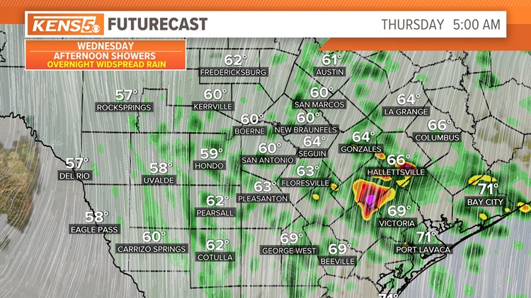
In addition to the rain, fog could develop by late Wednesday night and storm activity could develop to the east of San Antonio.
Here's what San Antonians can expect:
Wednesday (High 59 and Low 46): Cloudy skies will begin during the morning and temperatures in the low 50s. Southeasterly wind will also take place increasing moisture by the evening. Since the clouds hang around for most of the day temperatures will stay in the low 60s all day. So keep the jacket nearby.
Thursday (High 74 and Low 54): A warmer day is in store for the afternoon. You will want to dress in layers as the temperatures will start in the 60s but could reach the low 70s by the afternoon. This will be the warmest day of the week.
This is also the day scattered shower activity will begin by early morning in San Antonio and the heavier storms will stay to the east of I-35. The heaviest rain should be gone by the afternoon. Overall, San Antonio will not see impressive rainfall, only about 0.15''.
Friday (High 69 and Low 52): Skies will start to clear by the afternoon and temperatures still be mild near 70 degrees. However, temperatures will start out cold in the 50s for Friday morning. A north wind will also hang around for the morning with dry air leaving for a very pleasant day. This will be an excellent evening to check out some Christmas lights along the River Walk.
The weekend: Saturday and Sunday temperatures could start out cold in the upper 40s thanks to dry air under mostly cloudy skies. San Antonians have a slight chance of rain on Saturday and temperatures will warm to the upper 60s and on Sunday reach the 70s.


