HOUSTON — EDITOR'S NOTE: We are keeping all Beta updates on a new page. Tap or click for the latest track of Tropical Storm Beta.
___________________________________________________________
Tropical Storm Beta continues moving through the Gulf of Mexico. It's expected to strengthen into a hurricane, according to the National Hurricane Center.
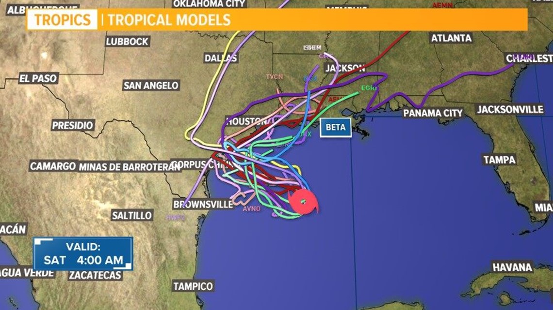
The forecast track for the Gulf system remains uncertain.
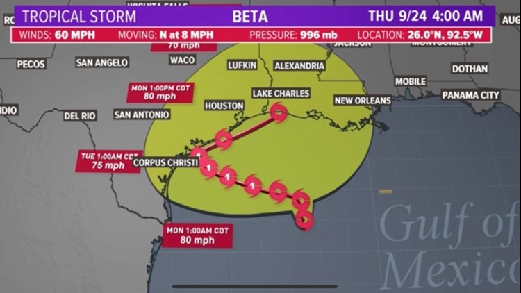
As of 4 a.m. Saturday, Tropical Storm Beta had 60 mph sustained winds with gusts at 70. It was moving to the north at 8 mph. It's 300 miles southwest of the mouth of the Mississippi River.
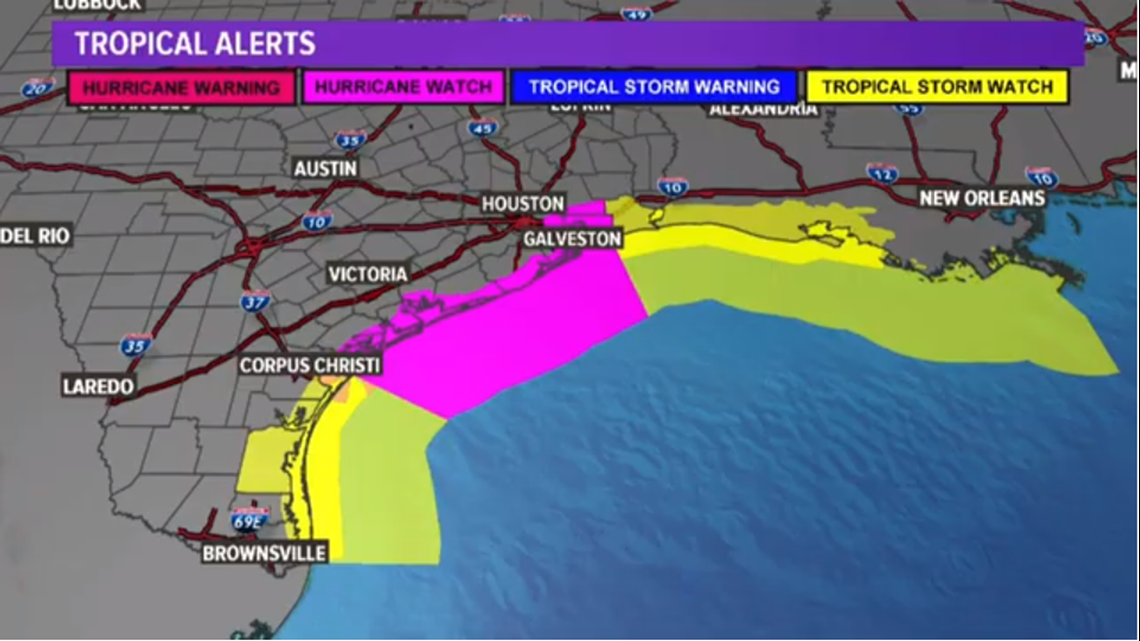
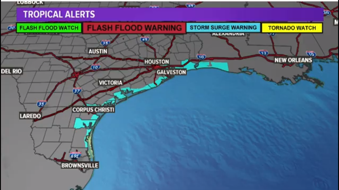
Hurricane and storm surge watches are in effect from Port Mansfield to High Island. Significant flooding is expected to produce damage to beaches and dunes.
Timing of Tropical Storm Beta
We expect Beta to make a westerly turn and then ride up the Texas coast either as a tropical storm or a Category 1 hurricane over the course of the weekend.
By Sunday afternoon/evening, our rain chances here in Houston will start to increase.
Beta is forecast to be a Category 1 hurricane just east of Corpus Christi by midday Sunday.
The current forecast has it reaching the Texas coast early in the work week (Monday evening into Tuesday morning), and then moving parallel to the coast through Wednesday night.
The Houston area is on the dirty side for much of that time, meaning we'll get the brunt of it the storm as the onshore flow will bring moisture off the Gulf, giving us rain and wind. Although, by the coast, you’ll be more impacted that north and west of Harris County.
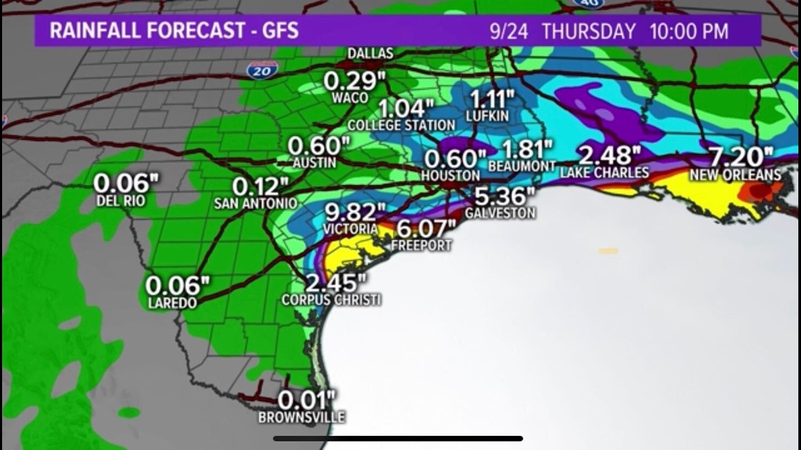
Over a three day time frame -- Monday, Tuesday and Wednesday -- we'll see the most rain and have the biggest flooding threat.
Key messages from National Hurricane Center (4 a.m. Sat.)
- There is an increasing risk of heavy rainfall along the northwest Gulf Coast Sunday through at least the middle of next week as Beta is forecast to move slowly toward and along or offshore of the coast through that time.
- Life-threatening storm surge and hurricane-force winds are possible along portions of the Texas coast early next week with tropical storm conditions possible by late this weekend. Storm surge and hurricane watches are in effect and residents in these area should ensure they have their hurricane plan in place and follow advice given by local officials.
RELATED: Galveston County considers voluntary evacuation of Bolivar Peninsula ahead of Tropical Storm Beta
Tropical Storm Beta forecast cone


Tropical Storm Beta spaghetti models

Gulf Coast rainfall forecast estimates

Current watches and warnings
Hurricane and storm surge watches have been issued from Port Mansfield to High Island. Significant coastal flooding may produce significant damage to beaches and dunes.


4 a.m. Saturday update from the National Hurricane Center:
Beta has generally changed little overnight. The storm is still quite asymmetric due to southwesterly wind shear with the low-level center located near the southwestern edge of the main area of deep convection. An ASCAT pass from a few hours ago showed peak winds in the 40-45 kt range, with most of the tropical-storm-force winds on the north side of the circulation. In addition, the latest Dvorak classifications are 3.0/45 kt from TAFB and SAB. The initial intensity of 50 kt, based on the earlier aircraft data, is a little above the satellite estimates. The Air Force Hurricane Hunters are scheduled to investigate Beta again later this morning, and the data they collect will provide a better estimate of the intensity and structure of the storm.
Beta is moving northward, with the latest initial motion estimated to be 360/7 kt. The shortwave trough that has been causing the north to northeastward motion during the past day or so is moving away and a weak mid-level ridge is expected to build to the north of the storm soon. This change in the steering pattern should cause Beta to turn westward and slow down later today and then move generally westward to northwestward through the remainder of the weekend and into early next week. This motion should take Beta toward the Texas coast by Monday.
Around the time Beta is forecast to be near the Texas coastline, the ridge is expected to retreat as another shortwave trough approaches, which should cause the storm to slow down even more and gradually turn to the northeast near the Texas coast by the middle of next week. The models are in fair agreement, and the NHC track forecast lies close to the various consensus aids.
As mentioned above, the tropical storm is still feeling some effects of southwesterly wind shear, but the upper-level pattern is expected to become more favorable for strengthening later today. Although the shear is expected to lessen, water vapor images show a swath of dry air approaching the storm from the west. Based on these mixed environmental conditions, slow strengthening is forecast during the next couple of days and Beta is forecast to reach hurricane intensity in about 36 hours. Beyond a few days, the models suggest that there could be another increase in southwesterly shear, which in combination with land interaction should cause some weakening. Of course, the rate of weakening will depend on whether Beta is inland or offshore. The NHC intensity forecast is largely an update of the previous one and lies at the high end of the model guidance.
Be prepared if tropical weather does come our way
BEFORE THE STORM
- Make a home inventory
- Have a current copy of your declarations page that has your policy number and your agent's number
- Review your policy with your insurance agent to determine if you have adequate coverage
- Repair loose boards, shingles, shutters and downspouts to prevent them from becoming an issue in high winds or torrential rain
- Have an evacuation plan, and include plans for your pets
- Make sure your emergency equipment is in working order, including a battery-powered radio, flashlights and extra batteries. Also, make sure to gather all medicine, replenish your first-aid kit and stock a week's worth of non-perishable food and water
- Charge your cell phone and fill your car with gas
- Program all emergency phone numbers
DURING THE STORM
- If you are advised to evacuate, leave as soon as possible. Retain all related receipts - they may be considered in your claim. If you aren't in a recommended evacuation and you plant to stay home, stay informed by listening to weather alerts
- Keep windows and doors closed at all time, and, if possible, board them up with wooden or metal shutters
- Stay away from the windows and in the center of the room, or, stay in an interior room
- Avoid flood water, as it may be electrically charged from downed power lines
- Check on family members and friends
AFTER THE STORM
- Check to be sure your family members are safe
- If you did evacuate, wait for official notice that it is safe to re-enter your neighborhood and your house
- Document damaged property, and take photos and videos. Don't dispose of any damaged items without approval
- Keep a record of any temporary repairs or expenses to prevent further damage to your property

