

SAN ANTONIO — If one thing could unite San Antonians during our historically hot summer, it was a desire for much-needed and sorely-lacking rain to cool us down during a stretch when it seemed the 100-degree days would never end.
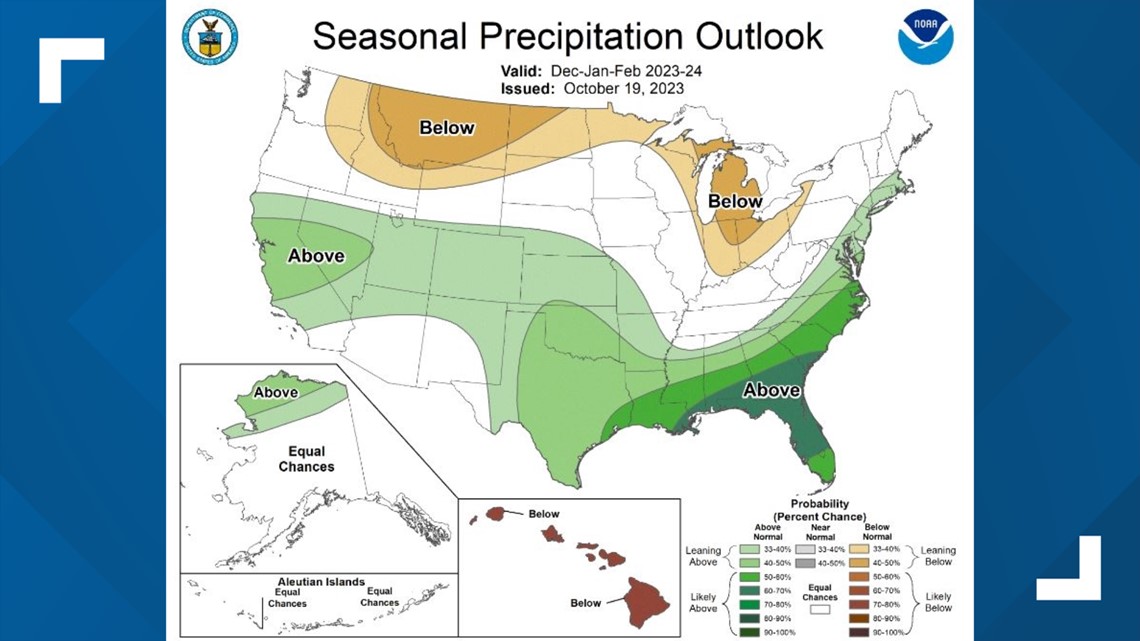
According to the U.S. Winter Outlook released Thursday by NOAA, we'll be getting our wish in the coming months. The report predicts higher-than-average precipitation for almost the entirety of Texas from December to February, with the San Antonio region seeing a 40% to 50% chance of wetter conditions than we normally see during the winter months.
According to National Weather Service data, San Antonio historically sees about 5.7 inches of precipitation during the winter season. (NOAA doesn't provide an extensive outlook on potential snowfall, as it's hard to predict snow more than a week in advance.)

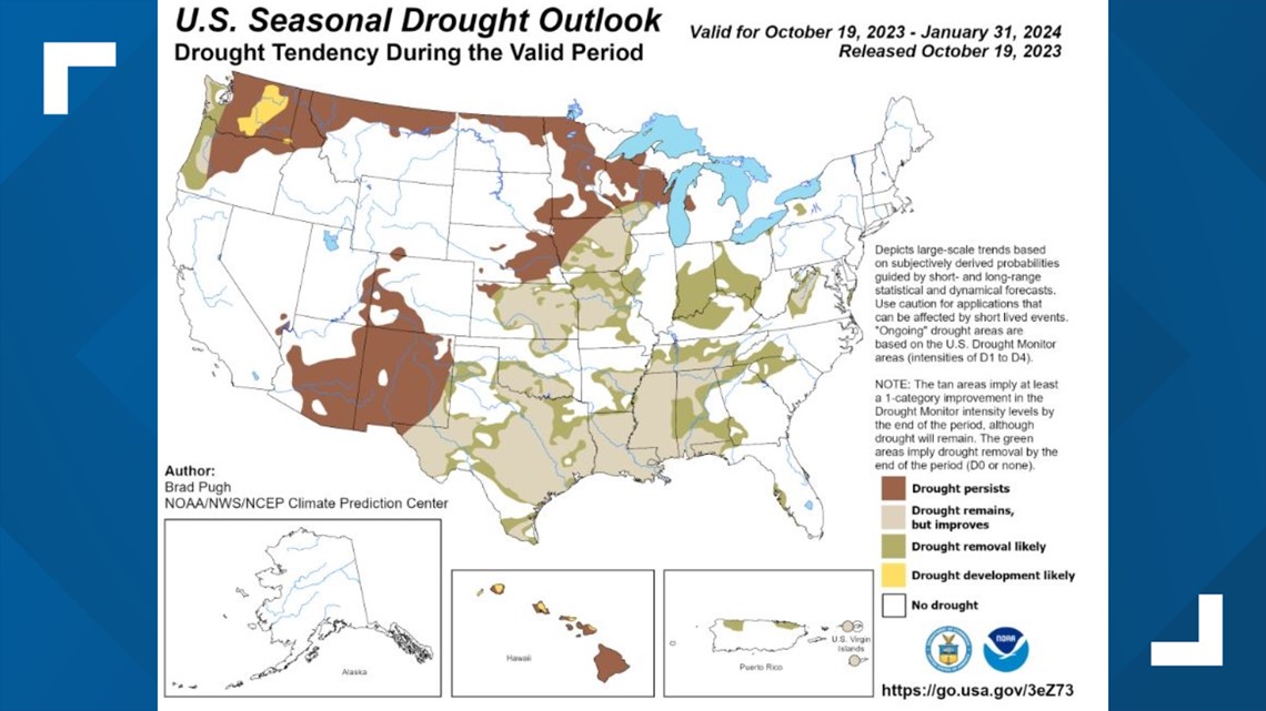
The report also brings good news for a South Texas region with areas that have been under extreme or exceptional drought for months, including Bexar County. According to NOAA, San Antonians can expect improving drought conditions until the end of January, thanks in part to extra precipitation that's expected (though it won't be enough to completely rid the region of drought).

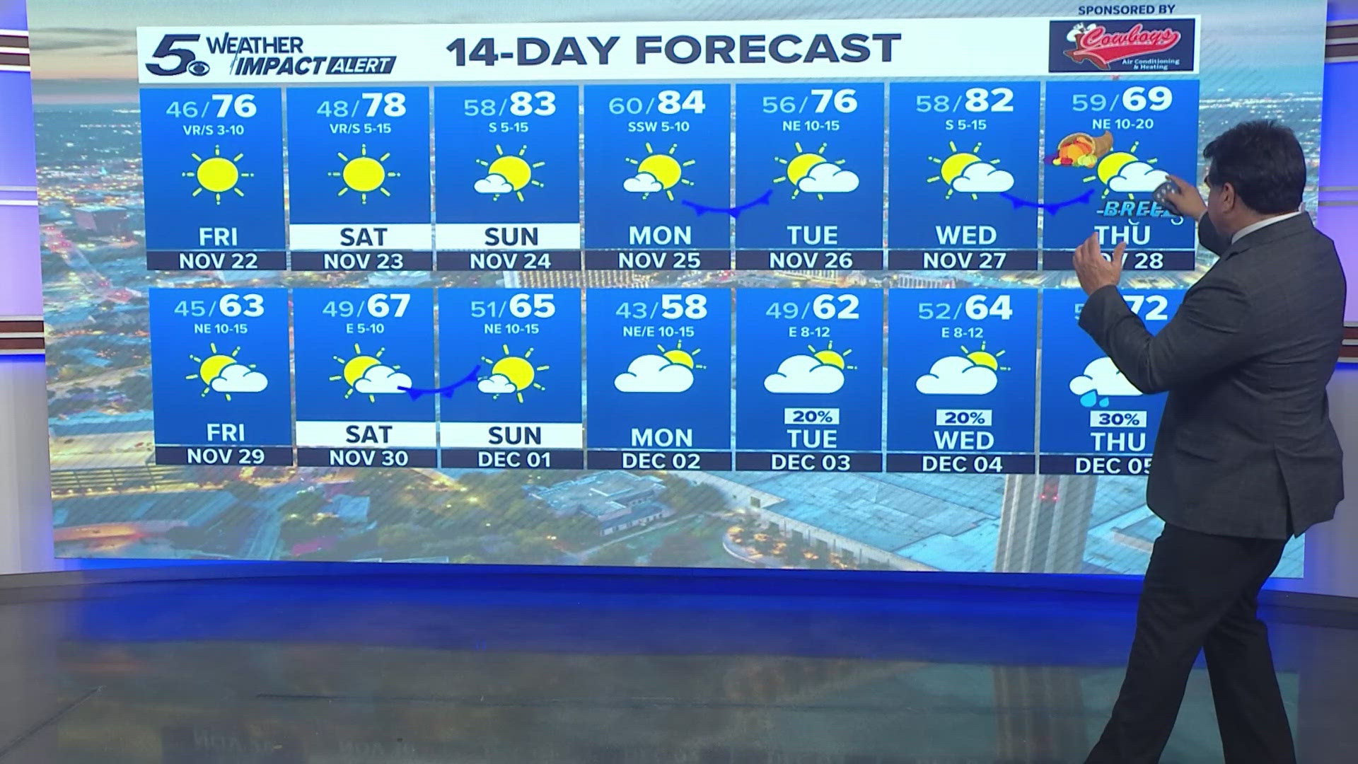
As for how high or low the mercury will go, South Texas is in for a seasonal winter. Per NWS data for the Alamo City, that means we'll generally see temperatures dipping into the low-to-mid 40s while reaching into the mid-60s during the winter afternoons.
NOAA chalks its winter climate predictions – which also calls for warmer-than-normal conditions in Alaska and across the Pacific Northwest and Midwest regions, as well as much rainier days for most of Florida – up to El Niño conditions being in place "heading into winter for the first time in four years."
“An enhanced southern jet stream and associated moisture often present during strong El Niño events supports high odds for above-average precipitation for the Gulf Coast, lower Mississippi Valley and Southeast states this winter,” Jon Gottschalck, chief of the Operational Prediction Branch of NOAA's Climate Prediction Center, is quoted as saying in the report.
What about the rest of October?
Of course, these predictions are for weather that won't kick in until Dec. 21. From Halloween events to pumpkin-picking and fall festivals, there's reason for residents to want to know what the weather will be like in the coming days.
We're expecting a warm weekend of near-record-high temperatures of 94 and 93 on Friday and Saturday, respectively, before cooler and wetter conditions settle in at the start of next week. Monday and Tuesday will both bring a 40% chance of rain, while a 30% chance awaits on Wednesday.
>TRENDING ON KENS 5 YOUTUBE: