

SAN ANTONIO — Heavy rain and storms are moving out of the San Antonio area Monday morning after heavy storms roll through the region, bringing heavy downpours and dangerous travel conditions. The National Weather Service says drivers should still use caution on flooded roadways.
A previous Flood Warning issued by the National Weather Service, affects parts of Bexar, Comal, Medina and Atascosa counties expired at 5 a.m.
Outages:
At one point Sunday night, as many as 3,000 customers were without power, according to CPS Energy. As of 7:30 a.m., the outage map shows around 1,300 customers without power.
Check the outage map below:
Traffic:
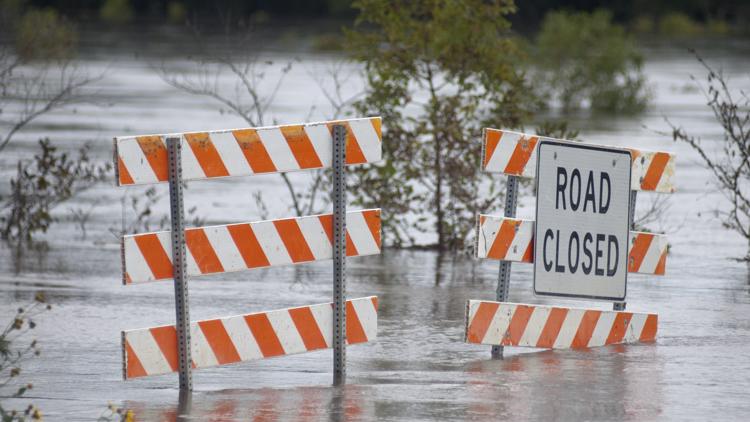
The heavy rain is causing some road closures Monday morning. Take a look at the map below which shows road closed in Bexar County Monday morning.
The city of New Braunfels also says Goodwin Lane at Alligator Creek has been closed.
There is water on the roads elsewhere in the San Antonio area. Take a look at a rotating traffic cameras showing water on the roads around the area.
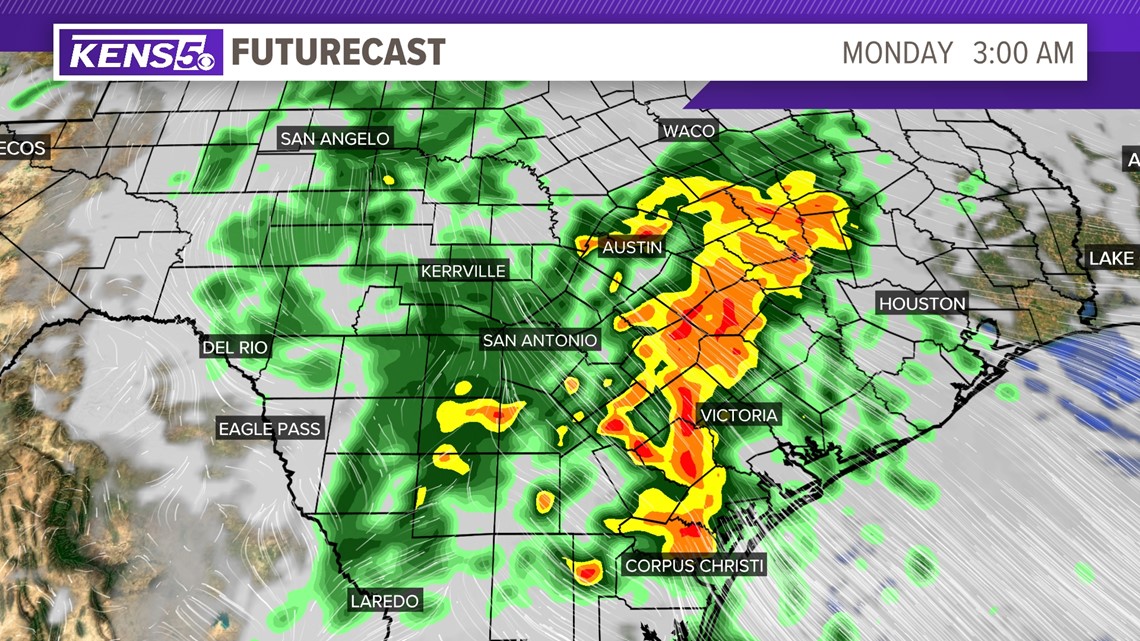
NWS officials said just before midnight Sunday that some areas had already seen two inches of rain. Another one and a half to two inches are possible by 10 a.m. Monday, with even more rain being dumped on cities east of San Antonio.


More than 20 Bexar County roads were closed as of 1 a.m. due to flooding concerns, mostly on the north side. And CPS Energy crews were responding to overnight outages, with more than 2,000 customers without power as of 1:15 a.m.
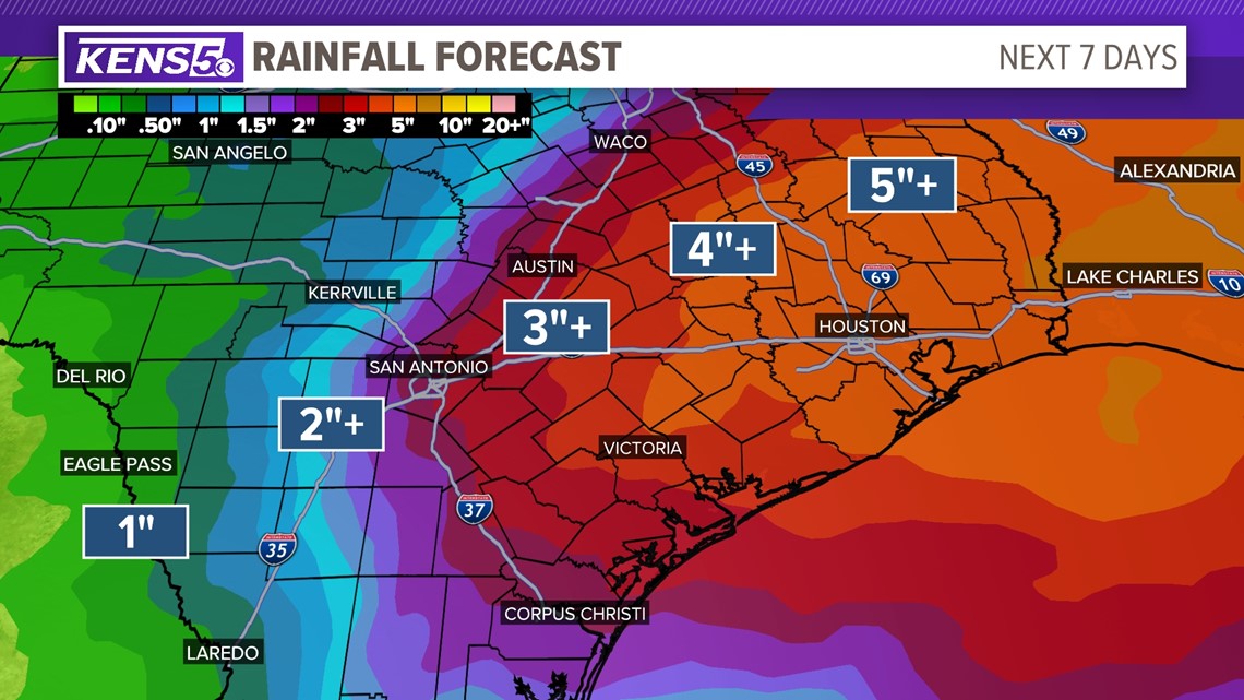
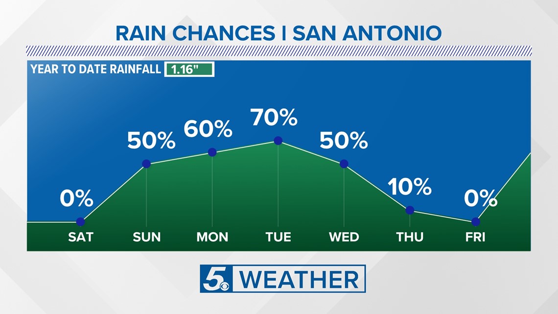
This is just the start of what's expected to be a very wet week for very dry south-central Texas. Most of Bexar County has been experiencing exceptional or extreme drought for a year or more, according to the U.S. Drought Monitor.
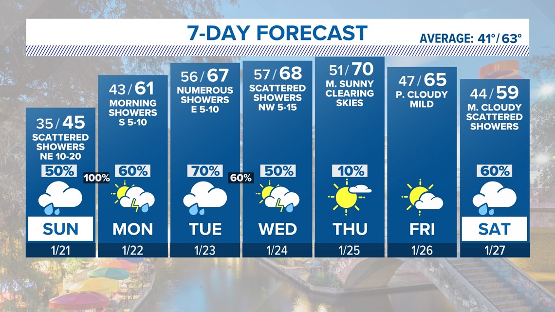
Most of the week will see moderate-to-strong chances of rain and relatively warmer temperatures after last week's cold snap, meaning the potential for flooding likely won't stop when the Flash Flood Warning expires Monday morning.


This is a developing weather event. Refresh the page for the latest updates.
---
SEVERE WEATHER 101
When severe weather threatens the area, it is important to know what risks a storm can bring and what you should do to stay safe.
One of the most important things to know is where you are located on a map, so when a watch or warning is put into place, you can identify if you are at risk. When the National Weather Service puts out warnings, they are county-based and sometimes include cities as well. It is important to know where you live in the county and that you can identify it on a map.
It is also important to know the difference between a watch and a warning. A watch means that conditions are favorable for something to happen, but a warning means that something has developed and it is important to take action.
So, what would cause a thunderstorm to be qualified as a "severe" thunderstorm?
Hail that is one inch large is also considered to be about the size of a quarter.
Another ingredient that would lead to a storm becoming severe is if winds are 58 mph or greater.
Winds at this strength could cause damage to roofs and could even cause trees to be knocked down.
Finally, if a tornado is present inside a thunderstorm it would qualify the storm as becoming severe.
In this instance, a tornado warning would be issued.
A tornado watch can be issued for an area if strong storms are expected, and if the storms bring the risk for tornadoes, but not all storms include the threat for tornadoes. The ingredients in the atmosphere for a tornado to form are not always there when storms are present.
If the area you are in is ever under a tornado warning, it is important to know where you should go inside your home.
Head to the lowest, interior room of your home. The basement would be best, but if you don't have one, head to the first floor of the home and get away from exterior walls, or walls that lead to the outside of the home.
It is also important to stay away from glass. The more walls you can put between you and the outside, the better.
While lightning can be frequent in storms and very dangerous, it does not lead to a storm being qualified as severe.
Remember, when thunder roars, go indoors.
Storms can also lead to flooding. Flooding may not cause a storm to be labeled as being severe, but it is the deadliest kind of weather.
South Texas is known to have major flood events every few years, so it is important to use caution and to always stay out of floodwaters. Remember, turn around, don't drown.
Entering flood water is very dangerous as you can be swept off of your feet and you don't know what could be in the water that could hurt you.
The best thing you can do to be ready for severe weather is know what you will do in the event it strikes where you live.
Make sure your family has a severe weather action plan.
Have a place everyone goes inside your home and keep supplies there, such as food, medication, batteries, and flashlights.
Weather Minds Classroom: Take a class in Severe Weather 101
Follow the KENS 5 Weather Team
Don't forget you can download the KENS 5 app for the latest news and weather information each day while you are on the go.